Hiking Trails: The Rings Trail, Mojave National Preserve
Mojave National Preserve is a hidden gem in California's Mojave Desert, located roughly south of Death Valley National Park and north of Joshua Tree National Park. The preserve's website and brochures claim "Desert solitude in Southern California," and that is an accurate statement! While tourists and weekenders from L.A. are waiting in line at entrance stations and jostling for available campsites at Death Valley, Joshua Tree, and Anza-Borrego Desert State Park, hikers, campers, naturalists and solitude-seekers will find the peace they seek at Mojave National Preserve.

The preserve is home to Bighorn Sheep (Ovis canadensis) and endangered Desert Tortoise (Gopherus agassizii). Its 1.6 million acres boast a larger Joshua Tree woodland than Joshua Tree National Park, and more extensive sand dunes than Death Valley. And I was very impressed by the spring wildflower display here!
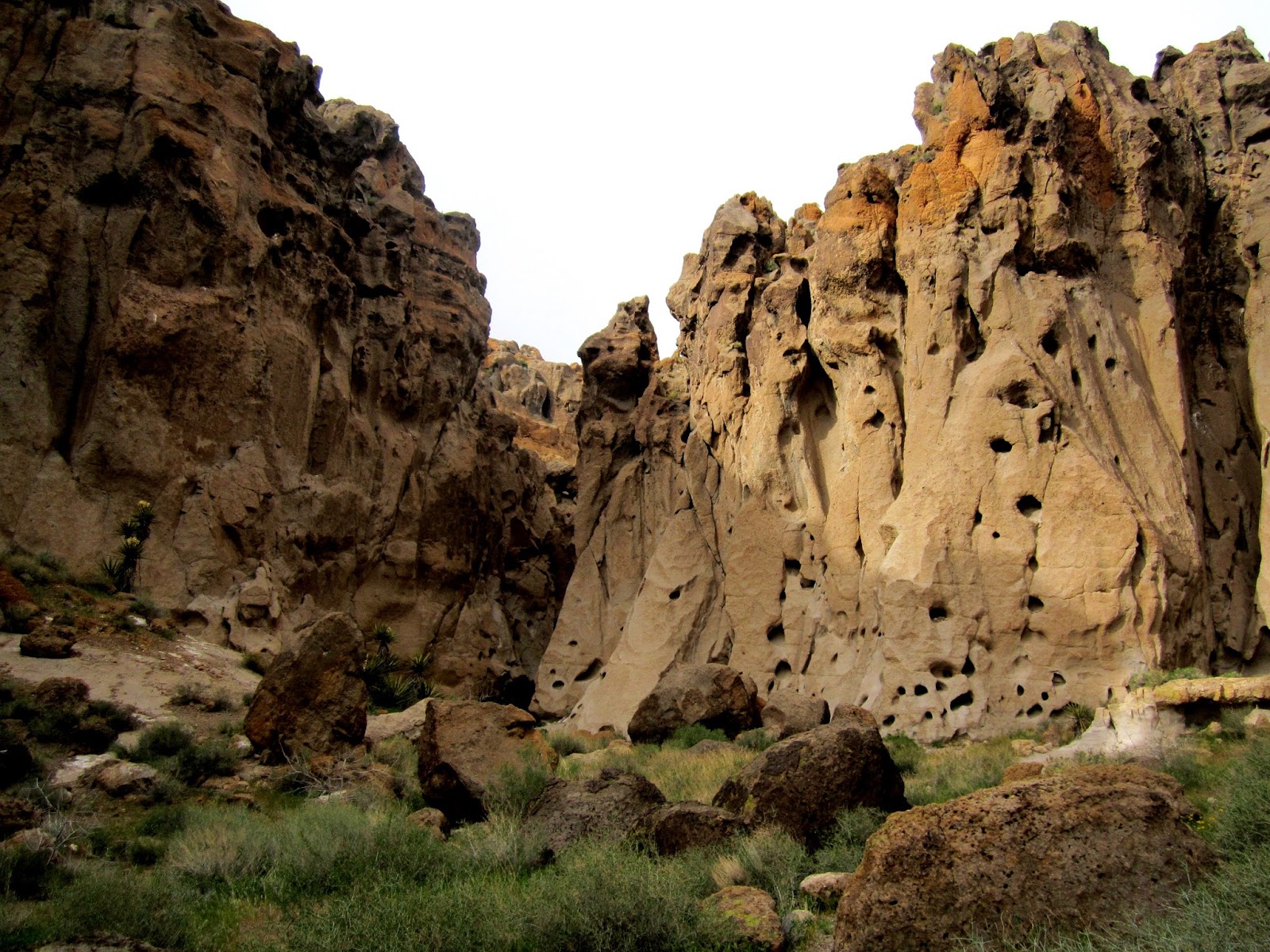 |
| The mouth of Banshee Canyon |
One of my favorite things to do on any outdoor adventure is to hike - just pack a daypack and head out on foot to see what there is to see. I find that more often than not, the simplest things really are the best. So I'm always on the lookout for good hiking trails.
The Rings Trail at Mojave National Preserve is a short 1.5 mile loop, with just a little excitement built in. The trail begins at the Hole-in-the-Wall visitor center and descends through Banshee Canyon.
 |
| A portion of the Rings Trail through Banshee Canyon |
Hikers scramble down dry falls in the narrow canyon (or up, depending on which way you're traveling around the loop). A series of mounted rings are bolted into the rocks to make the scramble a little easier. This is the fun part of the hike! Feel free to do this section more than once (we did!)
 |
| The namesake rings |
The trail emerges from the mouth of Banshee Canyon, depositing hikers onto the desert floor with a stunning view of desert mesas composed of volcanic tuff (see the first photo in this post). At a junction with the Barber Peak loop trail, a left turn takes hikers around the south side of cliffs, past petroglyphs and back to the visitor center to complete the short loop.
 |
| Bighorn Sheep petroglyph |
It is also possible to connect the Rings Trail with the Barber Peak Trail to make a longer hike (not recommended in hot weather). The Barber Peak trailhead is also located at the Hole-in-the-Wall visitor center and the 6-mile loop trail circles Barber Peak, to the west of Hole-in-the-Wall campground.
More information on hiking in Mojave National Preserve can be found on their website: https://www.nps.gov/moja/planyourvisit/-hiking.htm
For a park map, visit https://www.nps.gov/moja/planyourvisit/maps.htm
 |
| The hiking professor ascending the rings |
For those interested in geology (and really, everyone should be!) the formation at Hole-in-the-Wall is noteworthy. The cliffs are volcanic tuff (ash deposits that were so hot, they solidified or welded into solid rock upon landing), most of which is part of the Wild Horse Mesa Tuff formation. The holes in the rock were formed by, a) gasses trapped in the ash, according to the sign at the trailhead, or, b) damp pockets in the tuff formation, caused by slight variations in the degree of solidification of the ash, which allowed minerals to decay into small particles that are easily eroded away, according to my geology professor. I'm not sure what to do about that seeming discrepancy in information. More research, I suppose is the answer! In any case, the holes have been further eroded by wind and water, and make excellent nesting sites for cliff-dwelling birds.


Comments
Post a Comment